Mapping severe weather hotspots by region shows where tornadoes, hurricanes, and thunderstorms frequently strike, allowing you to identify vulnerable areas. By analyzing historical data, atmospheric conditions, and climate trends, scientists pinpoint these high-risk zones. This information helps communities prepare and respond effectively, reducing damage and saving lives. Advances in satellite technology and weather models improve these maps over time. Keep exploring to discover how this information can help protect your region.
Key Takeaways
- Hotspots are identified through analysis of historical weather data, current atmospheric conditions, and climate change trends.
- Mapping tools utilize satellite imagery, weather models, and climate data to visualize vulnerable regions.
- Regional storm hotspots often cluster in specific areas prone to tornadoes, hurricanes, or thunderstorms.
- Climate impacts like rising temperatures and shifting jet streams can create new or more intense hotspots.
- Accurate mapping supports early warning systems and targeted disaster preparedness in vulnerable regions.
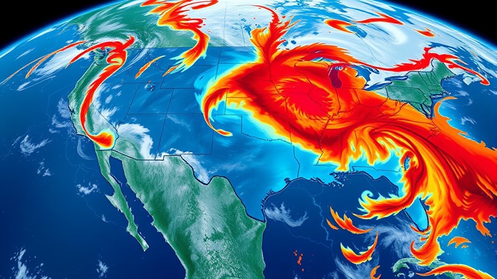
Severe weather events don’t occur randomly; they tend to cluster in specific regions, creating hotspots that pose ongoing risks. Understanding these patterns is essential if you want to stay prepared and protect your community. One of the key tools in this effort is storm prediction, which involves analyzing various atmospheric and environmental factors to forecast when and where severe weather might strike. By mapping these hotspots, meteorologists can identify areas most vulnerable to events like tornadoes, hurricanes, or intense thunderstorms. This targeted approach helps authorities allocate resources more effectively and issue timely warnings, reducing potential destruction and saving lives.
The climate impact plays a significant role in shaping these weather hotspots. As global temperatures rise, many regions experience more frequent and intense storms. Warmer air holds more moisture, which feeds storms and leads to increased rainfall and flooding. Additionally, shifts in jet streams and ocean currents influence storm paths and intensities, contributing to the formation of new hotspots or intensifying existing ones. When you consider climate impact, it becomes clear that these hotspots aren’t static; they evolve with changing climate patterns. This means that areas historically less affected by severe weather might now face higher risks, making ongoing mapping and prediction even more critical.
Mapping severe weather hotspots involves analyzing historical data, current atmospheric conditions, and climate trends. You can think of it as creating a detailed weather landscape that highlights vulnerable zones, allowing for more precise storm prediction. This process includes using satellite imagery, weather models, and climate data to identify patterns and forecast future risks. By doing so, authorities can develop early warning systems and disaster preparedness plans tailored to each region’s specific vulnerabilities. If you live in or near a known hotspot, understanding these maps can empower you to take proactive measures—such as reinforcing structures, preparing emergency kits, or staying alert during peak storm seasons.
Analyzing data and climate trends helps identify storm hotspots for better prediction and preparedness.
Furthermore, advancements in storm prediction technology, such as improved satellite sensors and data analytics, are enhancing our ability to forecast severe weather events more accurately and sooner.
In essence, mapping these hotspots isn’t just about understanding where storms tend to happen; it’s about anticipating their impact and reducing their harm. As climate impact continues to influence storm behavior, staying informed through accurate storm prediction becomes more essential than ever. This ongoing effort helps communities adapt to changing risks, ensuring you’re better equipped to respond when severe weather strikes. By recognizing these patterns and investing in predictive tools, we can better manage the dangers posed by clustered storm activity, ultimately saving lives and minimizing damage.

FosPower NOAA Emergency Weather Radio A1 7400mWh Portable Power Bank, AM/FM, USB/Solar/Hand Crank Charging, Battery Operated, SOS Alarm & Flashlight for Indoor/Outdoor Emergency – Orange
[7400mWh (2000mAh) POWER BANK WILL KEEP DEVICES POWERED] The FosPower FOSPWB-2376 emergency radio incorporates a 7400mWh (2000mAh) power…
As an affiliate, we earn on qualifying purchases.
As an affiliate, we earn on qualifying purchases.
Frequently Asked Questions
How Do Climate Change Trends Influence Severe Weather Hotspots?
Climate change trends increase severe weather hotspots by amplifying climate variability and disrupting atmospheric circulation patterns. You’ll notice more intense storms, heatwaves, and heavy rainfall in affected areas. As global temperatures rise, the atmosphere holds more moisture and energy, fueling extreme weather events. This shift makes hotspots more frequent and severe, affecting communities and ecosystems. Staying informed helps you prepare for these increasingly unpredictable and intense weather patterns driven by climate change.
What Technologies Are Used to Predict Regional Weather Hotspots Accurately?
Predicting regional weather hotspots is like having a weather crystal ball. You use satellite imaging to monitor cloud formations, temperature, and humidity in real-time, giving you a detailed view from above. Machine learning algorithms analyze this vast data, recognizing patterns that indicate severe weather risks. Together, these technologies help you forecast hotspots more accurately, enabling better preparedness and response to extreme weather events.
How Do Local Geography and Topography Impact Severe Weather Patterns?
You’ll notice that landform influence and terrain effects shape severe weather patterns considerably. Mountains can cause air to rise, triggering storms, while valleys might funnel winds, intensifying weather events. Coastal areas face unique challenges due to terrain effects that influence humidity and temperature changes. Understanding how local geography impacts these patterns helps you predict hotspots more accurately, emphasizing the importance of detailed topographic data in weather forecasting.
What Are the Economic Impacts of Severe Weather Hotspots on Communities?
Severe weather hotspots cause significant economic disruption, threatening your community’s stability and growth. You might worry about recovery, but strengthening community resilience can mitigate these impacts. Floods, storms, and droughts damage infrastructure, disrupt businesses, and increase costs. By investing in preparedness and adaptive strategies, you help protect livelihoods and foster recovery. Your proactive efforts guarantee your community remains strong, resilient, and capable of bouncing back from severe weather challenges.
How Can Policymakers Use Hotspot Data to Improve Disaster Preparedness?
You can use hotspot data to enhance disaster preparedness by engaging your community in planning efforts and raising awareness. This data helps you identify vulnerable areas, guiding targeted policy implementation for better resource allocation. By involving residents in preparedness initiatives and ensuring policies address hotspot risks, you create a proactive approach that minimizes damage and improves resilience during severe weather events. It’s all about turning data into actionable community strategies.

waterBOB Bathtub Emergency Water Storage Bladder Up To 100 Gallon Capacity – Food Grade Liner with Hand Pump for Hurricane and Disaster Preparedness – BPA Free Drinking Water Container
Space-Saving Up To 100-Gallon Emergency Water Storage: Transform your existing bathtub into a clean, safe water storage system…
As an affiliate, we earn on qualifying purchases.
As an affiliate, we earn on qualifying purchases.
Conclusion
As you explore these weather hotspots, remember, the latest data hints at more unpredictable storms on the horizon. Will these regions face even fiercer outbreaks soon? The patterns are shifting, and the next severe event could strike when you least expect it. Stay vigilant, stay prepared—because understanding where these hotspots are is just the beginning. The real question is, what’s coming next, and are you ready to face it?

Midland – WR120B – NOAA Emergency Weather Alert Radio – Localized Programming, Trilingual Display, 60+ Emergency Alerts, Alarm, Selectable Alert Tone
NOAA Weather Scan & Alert – This emergency weather alert radio features S.A.M.E localized programming and alert you…
As an affiliate, we earn on qualifying purchases.
As an affiliate, we earn on qualifying purchases.

XFasten Transparent Window Weather Sealing Tape, 2-Inch x 30 Yards (50.8mm x 27.43m), Clear Window Draft Isolation Sealing Film Tape, No Residue
STRONG BUT SURFACE-SAFE ADHESIVE. Transparent weather sealing tape is made of high-quality, weather-resistant materials that can withstand extreme…
As an affiliate, we earn on qualifying purchases.
As an affiliate, we earn on qualifying purchases.